 February 20, 2020 John E. Ross, KD8IDJ, Editor
| ||||||
Coronavirus Outbreak Postpones Swains Island W8S DXpedition The W8S DXpedition to Swains Island in the Pacific, set to take place in mid-March, has been postponed until September as a result of travel restrictions imposed on individuals entering American Samoa, stemming from the recent coronavirus outbreak. The Department of "Everything is prepared for our DXpedition, and we are eager to go, but unfortunately the coronavirus outbreak is out of our control," the DXpedition team said in announcing the delay. "Although this is a disappointment for everyone, the W8S DXpedition is not cancelled, just postponed for later this year." The DXpedition said it would alert the DX community as soon as it has new firm dates for the trip. VP8PJ South Orkney DXpedition Team Arrives The VP8PJ South Orkney DXpedition team, on board the Braveheart, reached Signy Island in the South Orkneys just after 1000 UTC on February 20. Team members are now preparing to land Zodiacs and transfer equipment. "We have ice to contend with regarding our planned landing area," the DXpedition reported. "The ice was pushed in during the previous days, but we are expecting the winds to change and blow the ice out. We are currently looking for an alternate site to unload, then move the The Perseverance DX Group-sponsored DXpedition was set to commence operation on February 20 (UTC), but it appears that could be delayed. Team members operated as ZL1NA/mm during their voyage, generating heavy pileups, and they expect to continue doing so once they get set up as VP8PJ. Operation on CW, SSB, RTTY, and FT8 (always fox/hound mode except on 60 meters) will continue until March 5 (UTC). Stations in Africa and Oceania may call at any time, regardless of operators' directional instructions. The VP8PJ DXpedition is the recipient of an ARRL Colvin Award grant, funded by an endowment established by Lloyd D. Colvin, W6KG (SK). Heading the 14-member DXpedition team are Dave Lloyd, K3EL, and Les Kalmus, W2LK. South Orkney Islands is the 16th most-wanted DXCC entity, according to Club Log. The DXpedition advises that DXers wait until propagation and conditions favor their location. VP8PJ will always operate split, and operators will indicate where they are listening. QSL via OQRS for direct or bureau, or direct via QSL Manager Tim Beaumont, M0URX; log search will also be available. Read more. --Thanks to The Daily DX for some information KX9X Offers Five Tips on Satellite Operating Etiquette Former ARRL Contest Branch Manager and Media and Public Relations Manager Sean Kutzko, KX9X, shared "Five Tips on Etiquette and Good Manners on the FM Ham Radio Satellites" on the DX Engineering blog, On All Bands. Kutzko said the transient nature of satellite availability can lead to "a natural sense of urgency" among operators trying to operate through it. "Satellite operating comes with several challenges, not the least of which is that it is one of the ultimate shared resources in the hobby," Kutzko wrote. "While there are now several satellites to choose from, a
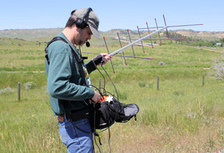
given satellite is only above the horizon for a maximum of 15 minutes or so. Lots of people trying to access a satellite during a short window of opportunity can create problems, and that can bring out some undesirable behavior." In terms of operating etiquette for satellites, Kutzko advised that the "big one," is "Don't transmit if you can't hear the satellite first." He notes that whistling or saying such things as "hello" and "check one-two" are bad form. "If you don't hear other activity, you're probably not going to hear yourself, either," Kutzko explained. "Blindly calling or whistling may cause unintentional interference to other stations that can properly hear the satellite." Next on the list is to wait your turn. "Given the rapid nature of satellite contacts, you shouldn't have to wait very long for your chance during a pass," Kutzko wrote. Kutzko also advised to always use phonetics when operating on the FM satellites. "Phonetics help ensure your call [sign] is copied correctly the first time and can save a lot of precious moments during a short pass," he said. Also, avoid making repeat contacts with a station you've worked previously and resist the temptation to greet an old friend. "[E]ach contact you make with a person you've already had several contacts with prevents another person from making a contact," Kutzko pointed out. Finally, he said, "It may be best to let the rare station have the pass and try to work as many stations as they can. In some cases, the rare station may only be audible for a portion of the pass you're on, with the station moving out of the satellite's footprint before it moves out of range for you," Kutzko recommended. "Satellite activity is at an all-time high, with new sats being launched on a regular basis and more operators discovering how much fun there is to be had," he concluded. "By being mindful of others trying to make contacts and thinking of others on the pass, we can all contribute to a better satellite environment for everyone." Kutzko won the June 2018 QST Cover Plaque Award for his article, "Get on the Satellites for ARRL Field Day." He steered satellite newcomers to his earlier blog posts to help them get started. ARRL Podcast Schedule
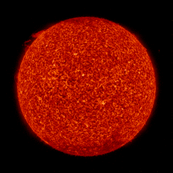
Both podcasts are available on iTunes (iOS) and Stitcher (Android) as well as on Blubrry -- On the Air | Eclectic Tech. The K7RA Solar Update Tad Cook, K7RA, Seattle, reports: The most recent sunspot appearance was on February 1, nearly 3 weeks ago. The average daily solar flux over the past week declined just barely, from 71.1 to 70.9. The average daily planetary A index changed from 8.3 to 7, and mid-latitude A index went from 6.7 to 5.1. Solar activity remains very low.
The predicted planetary A index is 18, 10, and 8 on February 20 - 22; 5 on February 23 - 25; 8 and 12 on February 26 - 27; 5 on February 28 - March 3; 20, 15, and 8 on March 4 - 6; 5 on March 7 - 14; 10, 8, 10, 8, and 5 on March 15 - 19; 10, 8, 5, 8, 12, and 10 on March 20 - 25; 5 on March 26 - 30; 20 on March 31, and 15, 8, 5, and 5 on April 1 - 4. Sunspot numbers for February 13 - 19 were 0, 0, 0, 0, 0, 0, and 0, with a mean of 0. The 10.7-centimeter flux was 71.2, 71.3, 70.6, 70.5, 70.7, 71, and 71, with a mean of 70.9. Estimated planetary A indices were 3, 3, 5, 3, 7, 14, and 14, with a mean of 7. The middle latitude A index was 1, 3, 4, 2, 5, 11, and 10, with a mean of 5.1. A comprehensive K7RA Solar Update is posted Fridays on the ARRL website. For more information concerning radio propagation, visit the ARRL Technical Information Service, read "What the Numbers Mean...," and check out K9LA's Propagation Page. A propagation bulletin archive is available. Monthly charts offer propagation projections between the US and a dozen DX locations. Share your reports and observations. Just Ahead in Radiosport
See the ARRL Contest Calendar for more information. For in-depth reporting on amateur radio contesting, subscribe to The ARRL Contest Update via your ARRL member profile email preferences. Emergency Communication Exercise Set in Northern Florida On Sunday, March 1, dozens of amateur radio volunteers from several states will take part in a 3-hour exercise in the northern Florida city of Gainesville. The exercise is designed to test and evaluate skills, assets, and strategies for emergency communication, such as those that might be needed in the aftermath of a hurricane. The exercise is being organized by the North Florida Amateur Radio Club (NFARC) This year's "Hot and Cold" exercise scenario is based on hypothetical high-pressure natural gas pipeline ruptures and subsequent fires, as well as a loss of electrical power during an extreme cold-weather event. The sudden widespread event then caused telecommunications failures in undersea cables to develop, with widespread communication systems overloading and failing. Exercise planners used the revised and just-released Homeland Security Exercise and Evaluation Program (HSEEP) in planning the event. The update incorporates feedback and input from exercise planners and practitioners across the country and ensures that HSEEP doctrine, the training course, and corresponding documents continue to best meet the needs of communities. Collaborating Amateur Radio Emergency Communications Conference lecturers have created a more than 200-page manual for the multi-track training sessions on Saturday. Participants will get to put what they learned into practice the next day, as they fan out to seven For the past 3 years, NFARC has published the conference proceedings, and last year, it also published the written report of its exercise. Last year's exercise scenario focused on a new respiratory virus that had crippled the nation. With the release of the updated 2020 HSEEP document, FEMA will be hosting webinars to provide information, highlights, and changes as a result of the review process. Webinars will continue until mid-May. Visit the HSEEP webpage for additional dates and times. -- Thanks to Dr. Gordon Gibby, KX4Z; The ARES E-Letter Mississippi ARES® Emergency Coordinator Credits Training for Effective Tornado Response Amateur Radio Emergency Service® (ARES®) volunteers in DeSoto County, Mississippi, devoted a January weekend to assisting local emergency managers in responding to tornado damage in the region. Desoto County Emergency Coordinator Ricky Chambers, KF5WVJ; Assistant EC Gene Adams, KF5KVL; Tate County EC Brad Kerley, KG5TTU, and Andy Luscomb, AG5FG, reported at 3 AM on January 11 to the DeSoto County Emergency Operations Center (EOC) to open Initial reports of downed trees blocking roadways and an eyewitness report of a possible tornado southwest of Hernando came in just after 5 AM. The ARES team at the EOC began taking damage reports, answering the telephone, and monitoring and taking calls from public safety dispatchers. When the deputy EMA director requested traffic control in Lewisburg, three of the ARES volunteers accompanied EMA director Chris Olson to Lewisburg. Chambers and Kerley assumed traffic A dozen ARES/RACES and EMA reservists returned the next day to conduct door-to-door damage assessment. For the next 10 days, Chambers reported, the DeSoto County volunteers assisted in handling telephone traffic in the EOC, freeing up first responders to do their primary jobs. "I attribute our effective response to the training we have conducted on a monthly basis," Chambers said, noting that training included recommended ARRL courses. "We were able to see how the Incident Command System worked on a first-hand basis as the incident unfolded, based on the ICS training courses we have taken. My group went from 0 to 110 MPH in seconds, never missing a beat [and] everyone performed on a professional level." -- Thanks to DeSoto County and EMA Reservist Coordinator EC Ricky Chambers, KF5WVJ Yasme Foundation Announces Grants and Excellence Awards The Yasme Foundation Board of Directors announced several grants when it met in Orlando, Florida, on February 9. Financial support will go to:
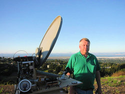
The Board also announced the individual and group recipients of the Yasme Excellence Award, which recognizes significant contributions to amateur radio through their service, creativity, effort, and dedication. The award may recognize technical, operating, or organizational achievement. The Yasme Excellence Award is in the form of a cash grant and an individually engraved crystal globe. The latest recipients of the Yasme Excellence Award are James Sarté, K2QI, and Adrian Ciuperca, KO8SCA, for their efforts in combining the latest state-of-the-art technology, diplomatic skills, persistence, and leadership in reactivating United Nations Headquarters club station 4U1UN. Additional help with gathering equipment and logistical support was provided by RA9USU, NT2Y, NT2X, K2LE, and N2UN (SK). The Yasme Foundation is a not-for-profit corporation organized to support scientific and educational projects related to amateur radio, including DXing and the introduction and promotion of amateur radio in developing countries. New World Distance Record Claimed on 122 GHz A new world distance record of 139 kilometers (86.2 miles) is being claimed by radio amateurs in northern California. This tops the record
of 114 kilometers set in 2005 by WA1ZMS and W4WWQ, according to the Distance Records on the ARRL website. The February 17, 2020, contact was between Mike Lavelle, K6ML, on Mount Vaca (CM88WJ75ON) at 835 meters (2,739.5 feet) above sea level, and Oliver Barrett, KB6BA (at 1225 UTC), and Jim Moss, N9JIM (at 1250 UTC), who were both on Mount Umunhum (CM97BD18VJ) at 1,016 meters (3333.3 feet) above sea level. Lavelle reports the dew point was -11 °C, the air temperature was 15 °C, the path loss was about 225 dB, and atmospheric loss was approximately 0.35 dB/kilometer. "CW was used, 122 GHz signals were very weak (7 dB above the noise in 22 Hz; -13 in 2500 Hz equivalent) with [fading] down to the noise floor," Lavelle told ARRL. "Dishes were aligned on 24 GHz (71 dB above the noise) prior to [moving] to 122 GHz; we heard signals right away on 122 GHz." The stations employed 60-centimeter satellite TV dishes and ran "somewhat less than half a milliwatt" on 122 GHz, Lavelle said. FAA's Proposed Remote Identification Rules Would Affect Drones, Hobby Planes The Federal Aviation Administration (FAA) is proposing to require remote identification of so-called "unmanned aircraft systems" (UAS), which include drones and hobby aircraft. A growing number of radio amateurs utilize camera-equipped drones for aerial photography purposes, to examine antenna systems, and to operate hobby aircraft remotely on amateur radio frequencies. Comments on the Notice of Proposed Rule Making (NPRM) in Docket FAA-2019-11, are due by March 2. "The remote identification of unmanned aircraft systems in the airspace of the United States would address safety, national security, and law enforcement concerns regarding the further integration of The FAA defines remote identification, or Remote ID, as the ability of an in-flight unmanned aircraft "to provide certain identification and location information that people on the ground and other airspace users can receive." The FAA called the move "an important building block in the unmanned traffic management ecosystem." "For example, the ability to identify and locate UAS operating in the airspace of the United States provides additional situational awareness to manned and unmanned aircraft," the FAA said. "This will become even more important as the number of UAS operations in all classes of airspace increases. In addition, the ability to identify and locate UAS provides critical information to law enforcement and other officials charged with ensuring public safety." The FAA said it envisions that the remote identification network "will form the foundation for the development of other technologies that can enable expanded operations." With few exceptions, all UAS operating in US airspace would be subject to the rule's requirements and would have to comply, "regardless of whether they conduct recreational or commercial operations, except those flying UAS that are not otherwise required to be registered under the FAA's existing rules." To comment, click on the "Submit a Formal Comment" button on the top of the Federal Register page that includes the NPRM text. In Brief...
Upcoming ARRL Section, State, and Division Conventions
Find conventions and hamfests in your area.
. .
Subscribe to...
Free of charge to ARRL members...
| ||||||
 | ||||||
 Solar flux is projected to remain very low -- 70 on February 20 - 27, and 71 on February 28 - April 4.
-Proceedings(1).jpg) and the Gainesville Amateur Radio Society (
and the Gainesville Amateur Radio Society (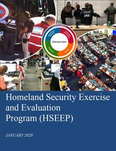 assigned simulated shelter locations and the Alachua County Emergency Operations Center. The club says Alachua County Emergency Manager Hal Grieb is supporting the volunteer-driven Homeland Security exercise and evaluation program-based effort, and he and his staff will serve as evaluators. Former FEMA Administrator Craig Fugate, KK4INZ, also plans to be on hand.
.jpg) a SKYWARN weather watch. After a tornado warning was issued for DeSoto County, Chambers activated an emergency net on a local repeater. Ten minutes into the net, however, the repeater went down, and the net switched to simplex. The net subsequently moved to another operational repeater.
a SKYWARN weather watch. After a tornado warning was issued for DeSoto County, Chambers activated an emergency net on a local repeater. Ten minutes into the net, however, the repeater went down, and the net switched to simplex. The net subsequently moved to another operational repeater.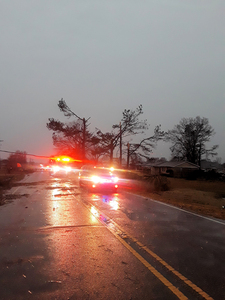 control, and Olson asked that Chambers put out a call for ARES/RACES volunteers and EMA reservists to report to the EOC. The ham radio volunteers also handled welfare checks.
.jpg) these aircraft into the airspace of the United States while also enabling greater operational capabilities," the FAA said in proposing the new requirements.
these aircraft into the airspace of the United States while also enabling greater operational capabilities," the FAA said in proposing the new requirements.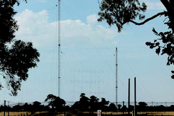 A Down Under special event will use former Radio Australia international broadcast antennas. Over the March 14 - 15 weekend, members of the Shepparton and District Amateur Radio Club (
 France has authorized use of 60-meter band. Telecommunications regulator ARCEP has authorized the use of a 60-meter band -- as agreed upon at World Radiocommunication Conference 2015 -- for French radio amateurs. The formal announcement was published in the Official Journal of the Republic of France (JORF) on February 13, IARU member-society REF (Réseau des Émetteurs Français) has reported. The 5351.5 - 5.366.6 MHz band will be available at a maximum EIRP of 15 W.
 ARISS radio telebridge stalwart Gerald Klatzko, ZS6BTD, has died. When the International Space Station (ISS) orbit is not favorable for a direct Amateur Radio on the International Space Station (